 |
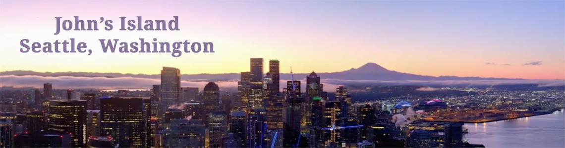
| Mount Baker as seen at dawn from Seattle. 6 spotting scope captures merged into a panorama. |
The following information is from Wikipedia
Mount Baker (Lummi: Qwú’mə Kwəlshéːn; Nooksack: Kw’eq Smaenit or Kwelshán), also known as Koma Kulshan or simply Kulshan, is an active glaciated andesitic stratovolcano in the Cascade Volcanic Arc and the North Cascades of Washington State in the United States. Mount Baker has the second-most thermally active crater in the Cascade Range after Mount Saint Helens. About 31 miles (50 km) due east of the city of Bellingham, Whatcom County, Mount Baker is the youngest volcano in the Mount Baker volcanic field. While volcanism has persisted here for some 1.5 million years, the current glaciated cone is likely no more than 140,000 years old, and possibly no older than 80-90,000 years. Older volcanic edifices have mostly eroded away due to glaciation.
After Mount Rainier, Mount Baker is the most heavily glaciated of the Cascade Range volcanoes; the volume of snow and ice on Mount Baker, 0.43 cu mi (1.79 km3) is greater than that of all the other Cascades volcanoes (except Rainier) combined. It is also one of the snowiest places in the world; in 1999, Mount Baker Ski Area, located 14 km (8.7 mi) to the northeast, set the world record for recorded snowfall in a single season—1,140 in (2,900 cm).
At 10,781 ft (3,286 m), it is the third-highest mountain in Washington State and the fifth-highest in the Cascade Range, if Little Tahoma Peak, a subpeak of Mount Rainier, is not counted. Located in the Mount Baker Wilderness, it is visible from much of Greater Victoria, Greater Vancouver, and, to the south, from Seattle (and on clear days Tacoma) in Washington.
Indigenous natives have known the mountain for thousands of years, but the first written record of the mountain is from the Spanish. Spanish explorer Gonzalo Lopez de Haro mapped it in 1790 as the Gran Montaña del Carmelo, "Great Mount Carmel". The explorer George Vancouver renamed the mountain for 3rd Lieutenant Joseph Baker of HMS Discovery, who saw it on April 30, 1792.
***********
Technical notes: At sunrise, of course, all we get is an outline of the mountain. Even so, it's not that common to have clear seeing on these very early (light-wise) mornings when the sunrise is in a more northerly direction and creates the nice outline. The scope is tripod mounted and the camera, the Sony RX100, is not directly connected to the scope, but rather mounted just beind the eyepiece. Getting a sharp focus is a chanllenge, and I'm not sure it was perfect here, but close enough. In creating the panorama, a little more time on the blending might have produced a picture without the darkness in the top center. According to Google Earth, the mountain summit is about 84 miles from the scope location in Seattle. The trees in the foreground are about 2 miles distant.


beautiful! love the soft color.
ReplyDeleteThere is nothing more beautiful and majestic to me than a clear view of a snow covered mountain top. I've often admired your Mt. Baker from the Canadian side.
ReplyDeleteThat is a great photograph.
ReplyDelete